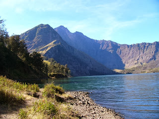
Mount Rinjani or Gunung Rinjani is an active volcano in Indonesia on the island of Lombok. Administratively the mountain is in the Regency of North Lombok, West Nusa Tenggara (Indonesian:Nusa Tenggara Barat, NTB). It rises to 3,726 metres (12,224 ft), making it the second highest volcano in Indonesia.
On the top of the volcano is a 6 km by 8.5 km caldera, which is filled partially by the crater lake known as Segara Anak (Child of the Sea). This lake is approximately 2000 metres above sea level and estimated at being around 200 metres deep; the caldera also contains hot springs.
On the top of the volcano is a 6 km by 8.5 km caldera, which is filled partially by the crater lake known as Segara Anak (Child of the Sea). This lake is approximately 2000 metres above sea level and estimated at being around 200 metres deep; the caldera also contains hot springs.
Lombok is one of the Lesser Sunda Islands, a small archipelago which, from west to east, consists of Bali, Lombok, Sumbawa, Flores, Sumba and the Timor islands; all are located at the edge of the Australian continental shelf. Volcanoes in the area are formed due to the action of oceanic crusts and the movement of the shelf itself.[4] Rinjani is one of at least 129 active volcanoes in Indonesia, four of which belong to the volcanoes of the Sunda Arc trench system forming part of the Pacific Ring of Fire – a section of fault lines stretching from the Western Hemisphere through Japan and South East Asia. The islands of Lombok and Sumbawa lie in the central portion of the Sunda Arc. The Sunda Arc is home to some of the world's most dangerous and explosive volcanoes. The eruption of nearby Mount Tambora on Sumbawa is known for the most violent eruption in recorded history on 15 April 1815, with a scale 7 on the VEI.
The highlands are forest clad and mostly undeveloped. The lowlands are highly cultivated. Rice, soybeans, coffee, tobacco, cotton, cinnamon, cacao, cloves, cassava, corn, coconuts, copra, bananas and vanilla are the major crops grown in the fertile soils of the island. The slopes are populated by the indigenous Sasak population. There are also some basic tourist related activities established on Rinjani primarily in or about the village of Senaru.
Rinjani volcano on the island of Lombok rises to 3,726 metres (12,224 ft), second in height among Indonesian volcanoes only to Sumatra's Kerinci volcano. Rinjani has a steep-sided conical profile when viewed from the east, but the western side of the compound volcano is truncated by the 6 x 8.5 km, oval-shaped Segara Anak caldera. The western half of the caldera contains a 230 metre-deep lake whose crescentic form results from growth of the post-caldera cone Barujari at the eastern end of the caldera.
(source: volcano.si.edu ; wikipedia.org )


No comments:
Post a Comment